

Source : Perth Now news
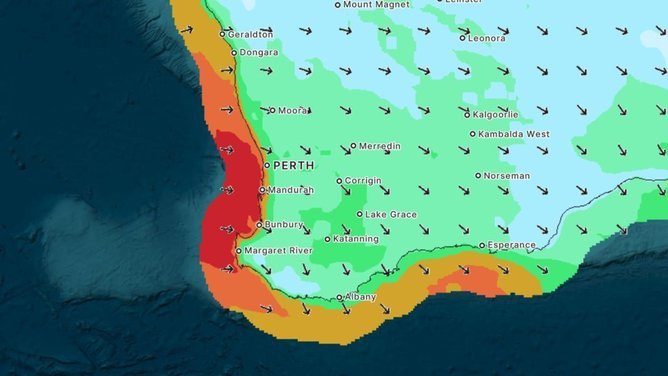
Residents of southern Western Australia have been put on notice as a low pressure system full of cold air hurdles towards the coast carrying “damaging to locally destructive winds” along with it.
Major towns and cities – including Perth, Margaret River, Bunbury and Mandurah – are all sitting on the frontline.
According to the Bureau of Meteorology, towns as far to the north west as Kalbarri and down to the south east near Israelite Bay are in the warning zone.
BOM meteorologist Sarah Scully says residents in the warning zone could expect “damaging to locally destructive winds, severe thunderstorms, areas of heavy rain, coastal hazards and even a risk of tornadoes” over the weekend.
“As we had into the weekend we’re expecting showers and rain areas to start to increase during Saturday and extend southward, reaching the Perth area around lunchtime,” Ms Scully said.
“However, it is during the afternoon that some gusty thunderstorms are expected to develop, and the winds will really start to increase.
“Damaging to locally destructive winds are expected to pick up about the coast and adjacent land areas.”

Ms Scully said the greatest period of risk for tornadoes would begin on Saturday night and end on Sunday morning.
“Any tornadoes that do form will be very short lived and very difficult to track,” she said.
The strongest winds are expected on Sunday evening as a low pressure system pushes up over Albany and then across towards The Bight into Monday.
“This low pressure system is also generating a huge amount of energy across the oceans, with very powerful waves and swells,’ Ms Scully said.
“The waves are expected to peak in the early hours of Monday morning with significant wave heights of eight metres.
“Where these very large waves coincide with high tides, this leads to an increased risk of coastal erosion as well as inundation of coastal areas.”

The WA Department of Fire and Emergency Services has urged residents of affected areas to actively avoid areas of potential danger including trees, power lines, storm water drains and streams.
On Saturday morning, BOM Senior Meteorologist Jonathan How said while WA would be experiencing “a bit of a hairy weekend,” the rest of the country would be experiencing fairly mild conditions.
“We’re finally seeing some sunny skies returning to the east coast, so great news for people in Brissy, Newcastle and down towards Sydney. We’ll see some sunshine returning around midday today,” Mr How said.
“The other big weather feature is a cold front moving through South Australia today and Victoria and Tassie tonight.
“That’ll bring a few more showers across the far southeast and the cooler air will see some snow settling across the Alpine areas later today.
“For northern Australia, there will be fairly clear skies and classic dry season conditions.”