

Source : Perth Now news
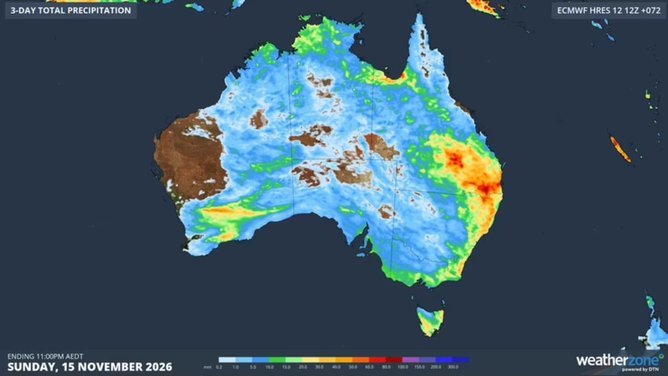
Millions of Australians will be in the firing line for a drenching as a band of rain, flash flooding, severe winds and possible hail as storms hit NSW and Queensland, over the next three days.
Parts of Queensland have already been pelted with more than 100mm of rain on Saturday, however the Bureau of Meteorology warns more is to come.
These storms are set to hit most of Queensland and eastern NSW east on Saturday, with
Sydney, Wollongong, Port Macquarie, Tamworth, Moree, and up into Queensland in Warwick, Roma and Charleville all in the firing line.
“These storms may bring heavy rainfall, that could lead to flash flooding, damaging winds, hail with a diameter greater than 2cms, developing (Saturday) afternoon and this evening,” BOM meteorologist Sarah Scully said.
The storms are expected to reach Sydney on Saturday evening, before an “even bigger storm day” is expected on Sunday, with Coffs Harbour and Port Macquarie warned of wild weather.
“Within this area, you could see giant-sized hail, with a diameter greater than 5cm, as well destructive wind gusts – in excess of 120 kilometres per hour,” Ms Scully said.
Severe thunderstorms are also possible for much of NSW and most of southern and southeastern Queensland.

On Monday, Gympie, Brisbane and South East Queensland and northern NSW are facing the likelihood of severe thunderstorms.
“Over the weekend, there is the potential for storms for both capital cities – Sydney and Brisbane,” Ms Scully said.
“For Sydney the most likely time being later (Saturday) evening. But for Brisbane, on Sunday and even continuing into Monday.
“And there’s the potential for damage to property, with wind damage to trees, trees being blown across roads. As well, powerlines to come down, causing power outages.
“And then of course the flash and riverine flooding can bring water across roads.”
Forecasters are predicting 1-9mm of rain for Sydney for Sunday, and five to 30mm on Monday.
In Brisbane, 1-15mm is forecast for Sunday and Monday.