Source : Perth Now news
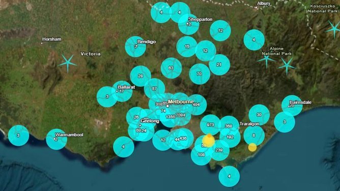
Victoria’s Gippsland region has been rocked by nine earthquakes in nine days, with tens of thousands of people reporting they felt the “ground shaking” to authorities.
The first earthquake hit Leongatha, southeast of Melbourne, and recorded a magnitude of 4.9 about 2am last Saturday.
More than 21,000 reports from people across Victoria, NSW and the ACT were registered by authorities.
Geoscience identified six aftershocks after the main earthquake and warned more aftershocks were possible.
The latest recorded a magnitude of 1.6 about 2.49pm on Thursday.
Geoscience seismologist Michelle Salmon expected aftershocks could potentially go on for months, but should get smaller with time.
She said while the Gippsland region was not the nation’s most seismically active area it did get a few jolts and because of its proximity to Melbourne people noticed them more.
“We don’t know when or where we are going to get a large event,” she said.
“Next Thursday is the Great Shakeout and it is a really good reminder to do your earthquake drill and know what to do when there is a big earthquake.”
Ms Salmon said a 6.7 magnitude earthquake had been recorded in Australia, and to put that in perspective, it had 100 times more shaking than the 4.9 magnitude recorded in Leongatha last Saturday.
“It’s always good to remember that you need to drop, cover, and hold on,” she said.
“Every magnitude you get is 10 times bigger, so if you had a 5.9 there would be 10 times more shaking.”

Geoscience Senior Seismologist Hadi Ghasemi said moderate to large earthquakes could occur anywhere across the continent, and without warning.
“On average, Australia experiences an earthquake of this size two or three times a year,” he said.
“It is important to note that it is not possible to predict precisely when or how large these earthquakes may be, or when the sequence will diminish to a point where they are no longer detectable.”
Dr Ghasemi explained Australia was not near a tectonic plate boundary, so earthquakes did not occur due to tectonic plates slipping past each other.
He said Australian earthquakes were a result of stress from the boundaries being transferred into our continental crust.
“The Australian plate is the fastest moving continental land mass on Earth that moves about 7cm per year, and is colliding into the Pacific plate to the north and east, and the Eurasian Plate to the northwest,” he said.
“This generates compressive stress in the interior of the Australian continent. Earthquakes are caused by the sudden release of this stress when rocks deep underground break and move along a fault line.”

The National Seismic Hazard Assessment identified the Gippsland area of Victoria as having a higher likelihood of earthquakes.
“That isn’t to say that this is the only part of Australia where earthquakes happen, but we know that there is a higher likelihood in this region,” he said.
“Other areas with a higher likelihood of earthquake activity include southwestern Western Australia, and in the Northern Territory around Darwin.
“When an earthquake occurs, no matter how large or small, we always ask people to lodge a ‘felt report’ on our website.
“Community felt reports help us better understand how strongly the earthquake was experienced across different locations.”