

source : the age
Tens of thousands of people remain without electricity and 11 schools are closed after storms battered south-east Queensland on Wednesday night, tearing down trees onto traffic and damaging roofs.
Parts of the region recorded between 50 to 80 millimetres in just half an hour, leading to flash flooding, and wind gusts of up to 96km/h.
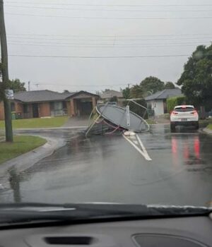
Intense gusts tore down trees and lifted a trampoline out of a backyard in Regents Park, Logan, while large hailstones were recorded west of the Gold Coast.
About 49,000 people remained without power in the Logan area by 6.30am on Thursday.
A falling tree knocked out traffic lights before crashing into cars on Aspen Circuit in Logan Reserve about 4pm. Another tree came down on Logan Road in Eight Mile Plains, striking two vehicles just before 5pm.
SES crews responded to more than 320 requests for help across the state’s south-east.
Most requests for assistance were related to fallen trees affecting structures or blocking the entry or exit to properties, and many needed tarpaulins for leaking roofs.
Among the hundreds of requests, 243 callouts were from Logan City. On Thursday morning, 11 schools in the area were closed.
Burrowes State School, Corymbia State School, Crestmead State School, Jimboomba State School, Logan Village State School, Marsden State High School, Marsden State School, South Rock State School, Yarrabilba State School, Yarrabilba State Secondary College and Yugumbir State School were closed.
A chance of thunderstorms remained for Thursday, meteorologist Jonathan How said.
“Today we still are seeing a lot of tropical moisture sticking around the east coast and that does mean that there’s a chance of thunderstorms again across much of central and south-east Queensland, as well as north-east and eastern parts of New South Wales,” How said.
“We could see severe thunderstorms developing again this afternoon, bringing heavy rainfall, damaging winds and large hail, and areas which could be impacted later today include Brisbane, the Sunshine Coast, the Gold Coast, as well as places like Bundaberg, Hervey Bay and inland towards the Darling Downs.
“So we are reminding communities to keep across those latest forecasts and warnings and the radar to the rest of today, with the possibility of more severe thunderstorms to come.”
The weather is expected to ease on Friday before a resurgence in storm activity at the weekend.
“Into the weekend, we do see those thunderstorms reinvigorate as another surface trough develops across inland parts of Queensland.”
Start the day with a summary of the day’s most important and interesting stories, analysis and insights. Sign up for our Morning Edition newsletter.