

Source : INDIA TODAY NEWS
El Nino has formed faster than India’s forecasters expected, and the monsoon is already paying for it. When India Today first reported this El Nino in May, both halves of the story were still forecasts: the Pacific was warming, and the India Meteorological Department was warning of a below-normal monsoon. In mid-June, both have hardened into fact.
On June 11, the United States’ National Oceanic and Atmospheric Administration declared that El Nino had formed and issued an advisory, putting a 63 per cent chance of it turning very strong by winter. India’s own weather office is more cautious, still calling the Pacific neutral but “transitioning toward El Nino”, a gap in thresholds, not direction.
advertisement
And it is forming on top of an ocean that is already close to its hottest. May 2026 ran neck and neck with 2024 as the warmest May on record for the world’s oceans, according to the European Union’s Copernicus climate service and the NOAA. The new warm phase is building on heat that never fully drained away.
MONSOONS ON KNIFE’S EDGE
India is not waiting to find out. On May 29, the IMD cut its seasonal outlook to a below-normal 90 per cent of the long-period average, down from the 92 per cent it had forecast on April 13. It raised the chance of a deficient season from 35 per cent to 60 per cent. It also put the odds of a below-normal-or-worse monsoon at 84 per cent. The monsoon core zone, which covers most of India’s rain-fed farmland, is most likely to finish below normal.
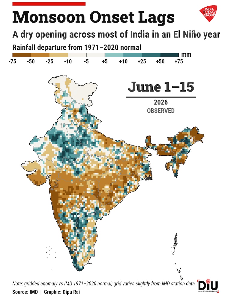
The season then opened to script. The monsoon reached Kerala on June 4, three days late but within the normal range, then underperformed. All-India rainfall ran 26 per cent below normal from June 1 to 10, and stayed thin through June 15, according to the IMD’s extended-range forecast.
The shortfall is uneven. The IMD’s gridded data shows the heaviest first-fortnight deficits over central, western, and southern India, while parts of the east and north-east ran closer to normal or wetter.
One of the monsoon’s usual cushions has also weakened. In April, the IMD had expected a positive Indian Ocean Dipole, a warm patch of sea off East Africa that often pulls extra moisture towards India. Cut to the June 11 outlook, this has been downgraded to neutral, with only a weak, late-season positive turn likely. The buffer that rescued some past El Nino monsoons looks thinner and later this time.
RESPONSE HAS ALREADY BEGUN
The numbers have prompted concern within the Union Ministry of Agriculture and Farmers Welfare, which has asked the Indian Council of Agricultural Research and state agricultural universities and departments to revise their contingency plans for an El Nino year before the kharif season peaks. The revised plans are due by June 20, according to Down To Earth.
The IMD forecast is only one input; the report adds that each district’s irrigation coverage, soil type, cropping pattern, and groundwater access are also being weighed to find where a weak monsoon will hit the hardest through drought and agricultural stress.
WHAT’S NEXT
India Today set out what a below-normal monsoon would mean for the country’s farms, food prices, and rural incomes in its first report in May. Two months on, the forecasts have become facts: El Nino has formed, the outlook has been cut, and the rains have dried up. The harder question is what India plants, stores and prices before this El Nino peaks over the Pacific this winter.
– Ends
SOURCE :- TIMES OF INDIA


