Source : Perth Now news
Western Australia’s second driest July on record is expected has ended this week with back-to-back cold fronts expected across the state.
Weatherzone reports the southwest of WA only received 42.05mm of average rain across the region over July this year – making it the second-lowest rainfall total on record after 2012, when the area average was 39.98mm
Climate change is widely understood to be the reason the southwest corner of Western Australia is being strongly affected declining rainfall in recent decades.
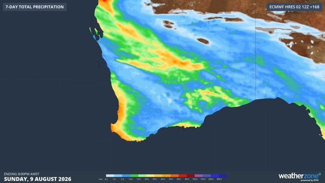
But new forecasts predicted over the next week spell the end of the so-called dry spell – with the heaviest falls of 5-15mm forecast to hit Perth through to Albany on Friday and Saturday.
Heavier, more isolated falls are expected in some coastal areas.
Meteorologist Caroline Crow, from the Bureau of Meteorology said that there even be some possible hail through the southern coastal areas.
“There is a cloud band extending from the Western Pilbara into central and southeastern parts of the state,” Ms Crow said.
“We’re seeing patchy rain out of that cloud band, which is expected to gradually weaken as we progress into this evening and through Wednesday.”

Another cold front in the in the southwest has moved over WA’s southeastern parts.
“For the southwest land division today, it’s just the chance of a shower mostly through the western and southern districts with some thunderstorms through the central and central southern parts of the state,” Ms Crow said.
The cloud band is expected to weaken on Wednesday and then gradually linger with patchy rain throughout the remainder of the week.
Another cold front is expected to hit the southwest of the state next week on Monday and Tuesday.