Source : Perth Now news
Australia is on track to record its wettest El Nino year yet, with widespread showers and thunderstorms forecast to soak large parts of the country over the coming week.
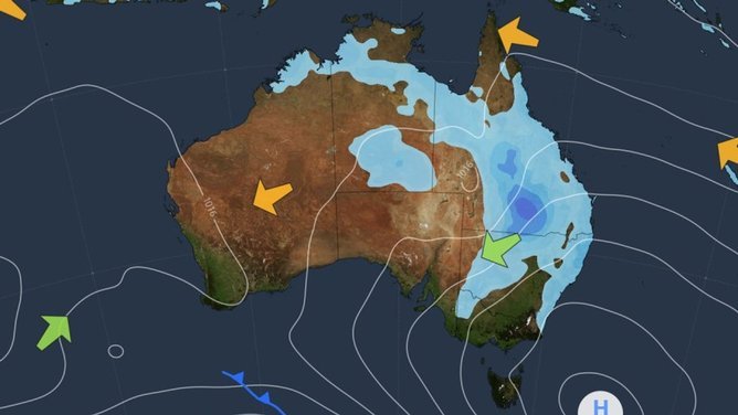
More than half the country could see showers and storms in the next seven days, with parts of Queensland and Northern NSW forecast to receive more than 50mm of rain, according to ABC meteorologist Tom Saunders.
Sydney has already been drenched by more than 100mm of rain this week, while Queensland has been hit by severe flash flooding and destructive winds have lashed Alice Springs, Mr Saunders said.
Queensland is expected to be the main focus for storms on Saturday with tropical moisture increasing the risk of intense thunderstorms and flash flooding, particularly inland south of Longreach.
Showers and storms are forecast to continue across Queensland and parts of NSW on Sunday, with the unsettled weather pattern expected to persist into next week.
The wet conditions are unusual given the strong El Nino in the Pacific and positive Indian Ocean Dipole, climate patterns associated with drier conditions across Australia.
Australia’s winter was the wettest for an El Nino year in 35 years, while national winter-spring rainfall was on track to exceed the long-term average, Mr Saunders said.

The latest weekly relative El Nino 3.4 index reached 2.81C above average for the week ending October 11, surpassing the previous weekly record of 2.78 degrees in November 2015, a Bureau of Meteorology spokeswoman said.
“The El Nino continues at near record ocean levels,” the spokeswoman said.
“The latest weekly relative El Nino index, ending the week, 11th of October is 2.81C, and this is the highest value on record.”
She said warmer sea surface temperatures around the Australian region could be supplying additional moisture into the atmosphere, contributing to the wet outlook.

Rainfall is forecast to be above average across much of Australia from November to January, although parts of the far north and south-east are expected to be drier than average, the spokeswoman said.
Warmer than average days and nights are also forecast across Australia over the next three-month period.


In today’s weather forecast, Sydney can expect a possible shower and a top of 21C on Saturday, while Newcastle and Wollongong are forecast to have a shower or two, reaching tops of 21C and 20C.
Brisbane is also in for a shower or two, with a maximum of 23C, while Cairns and Townsville are forecast to reach 29C with a shower or two. Darwin can expect a shower or two and a top of 34C, while Alice Springs could see a storm as temperatures climb to 33C.
Elsewhere, Melbourne and Albury-Wodonga are forecast to be sunny, reaching 25C and 23C. Perth and Adelaide can expect partly cloudy conditions with a top of 23C and 27C, while Broome is set for sunshine and a maximum of 33C.
Hobart is forecast to be sunny and reach 24C, while Canberra can expect partly cloudy conditions and a top of 20C.